p2distance 
p2distance computes the P2 distance synthetic indicator (Pena, 1977), a method for combining several partial indicators (quality of life, welfare, environmental quality, development) into a single measure that lets you compare different entities (countries, regions, cities…) on a common scale.
Unlike Principal Component Analysis or other traditional aggregation methods, P2 avoids arbitrary weighting: each variable is weighted by how much new information it contributes once the variables already included are accounted for, using an iterative correction based on each variable’s coefficient of determination (R²).
Installation
Install the released version from CRAN:
install.packages("p2distance")Or the development version from GitHub:
# install.packages("pak")
pak::pak("ajpelu/p2distance")
Example
p2distance ships with welfare, a dataset of 20 quality-of-life indicators for the 27 countries of the European Union (2002-2007, EurLIFE). Let’s rank countries by an overall welfare indicator:
library(p2distance)

data(welfare)
welfare_mat <- as.matrix(welfare)

ind <- p2distance(welfare_mat, reference_vector_function = min, iterations = 20)
#> [1] "Iteration 1"
#> [1] "Iteration 2"
#> [1] "Iteration 3"
#> [1] "Iteration 4"

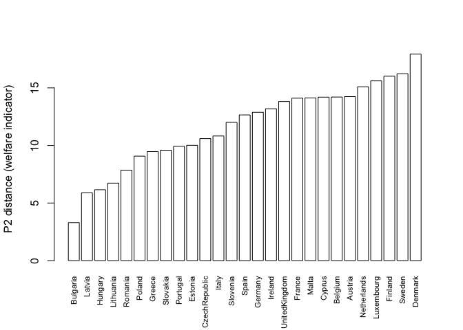
# Ranking (higher P2 distance = further from the reference = lower welfare)
sort(ind$p2distance[, 1])
#>      Bulgaria        Latvia       Hungary     Lithuania       Romania
#>      3.300577      5.881641      6.157913      6.728374      7.855658
#>        Poland        Greece      Slovakia      Portugal       Estonia
#>      9.072606      9.467627      9.584544      9.927800     10.014157
#> CzechRepublic         Italy      Slovenia         Spain       Germany
#>     10.595075     10.822846     12.005987     12.653989     12.882661
#>       Ireland UnitedKingdom        France         Malta        Cyprus
#>     13.186726     13.817885     14.106968     14.124929     14.196170
#>       Belgium       Austria   Netherlands    Luxembourg       Finland
#>     14.205152     14.243429     15.096630     15.608905     16.014650
#>        Sweden       Denmark
#>     16.225990     17.932001
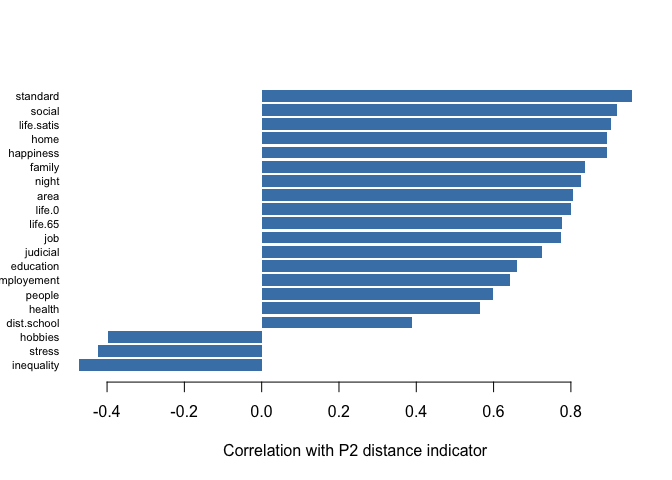
Each variable’s contribution to the indicator can also be inspected — here, how strongly each partial indicator correlates with the overall P2 distance:
barplot(
  sort(ind$cor.coeff[, 1]),
  horiz = TRUE, las = 1, col = "steelblue", border = NA,
  xlab = "Correlation with P2 distance indicator",
  cex.names = 0.7
)
barplot(
  sort(ind$p2distance[, 1]),
  las = 3, cex.names = 0.7, col = "white",
  ylab = "P2 distance (welfare indicator)"
)
Background
The P2 distance was proposed by the Spanish economist Jesús B. Pena Trapero to measure social welfare (Pena, 1977), and has since been applied to environmental quality indices, regional development, and inequality studies (see ?p2distance for the full formula and additional references). See the Impact article on the package website for real studies that have used p2distance, together with download statistics.
References
Pena, J. B. (1977). Problemas de la medición del bienestar y conceptos afines (una aplicación al caso Español). Madrid: Instituto Nacional de Estadística (INE).
Pena, J. B. (2009). La medición del bienestar social: una revisión crítica. Estudios de Economía Aplicada, 27(2), 299–324.
Code of Conduct
Please note that the p2distance project is released with a Contributor Code of Conduct. By contributing to this project, you agree to abide by its terms.